Vancouver Airport Skytrain Map
Vancouver Airport Skytrain Map - Route & Station Map, plus Info on Where to Connect to Buses for Tsawwassen & Horseshoe Bay Ferry Terminals
VTT Home › Vancouver Airport Transportation › Skytrain Map Of Vancouver Airport

By Darrin Robertson, VTT Editor - Updated:
January 17, 2023
Below you will find a guide map to the Skytrain route between YVR Airport, downtown Vancouver BC and Richmond BC, this map is printable and will help you use the Vancouver Skytrain. This is a custom-designed map from www.vancouver-travel-tips.com which shows not only all Skytrain station stops, but also where to connect to bus services for Tsawwassen & Horseshoe Bay Ferry terminals, as well as the Seabus to North Vancouver and othe Skytrain services. Vancouver Airport Skytrain Map Copyright © 2020 Vancouver Travel Tips.com Some of the most frequently asked questions about the YVR Skytrain: What are the Vancouver Airport Skytrain Hours of operation? Times vary according to route direction, but generally from about 5 AM in the morning to late night 1 AM. How long does it take to get from Vancouver Airport to downtown Vancouver on the Skytrain? About 25 minutes. What is the price of a ticket to ride the Skytrain from Vancouver Airport to downtown Vancouver? $7.75 1-zone fare of $2.75 + YVR AddFare of $5). A single zone ticket from the airport to downtown Richmond is $7.75 (2.75 plus YVR AddFare of $5). Discounts apply to seniors 65+, kids 5 to 13 (children 4 and under ride for free when with an adult), as well as travel weeknights after 6:30 PM, weekends and holidays. (Please Note: $5 YVR AddFare applies only to travel from YVR to Vancouver and Richmond. It is not paid for travel to YVR. How do I pay for Skytrain tickets? Automated ticket dispenser machines are located at each station. They accept cash, debit (ATM) and credit cards. Which Skytrain Station has the connecting to bus service to the Tsawwassen ferry terminal? Get off the Skytrain at Bridgeport Station and connect to Bus #620, which goes to the Tsawwassen Ferry Terminal. BC Ferry sailings from here go to Victoria, Nanaimo and the BC Gulf islands. Which Skytrain Station do I use to connect to the bus to Horseshoe Bay ferry terminal? Get off the Skytrain at City Centre Station, walk out to street level and proceed about 1/2 block east along Georgia St W. Here you will find stop #58504 which is the pick-up point for Bus #257, the express service to the Horseshoe Bay ferry terminal. BC Ferries have sailings from here to Nanaimo, BC as well as Gibsons, BC and Bowen Island. Disclaimer: This page is a general guide only - It is NOT the official Translink website. Skytrain schedules, fares and services are subject to frequent change. Vancouver Travel Tips.com accepts no responsibility for any loss, injury or inconvenience sustained by anyone resulting from this information. Please consult translink.ca and yvr.ca before starting any travel. Privacy Policy & Disclaimer / Contact Us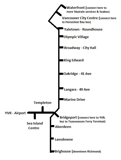
Vancouver Airport Skytrain Map Route - FAQ's:
More Info on Our Site: